Tropical Cyclones of the Pre-Industrial Era
Posted on: April 4, 2019


RELATED POST: [LINK]
THE HURRICANES LISTED HERE MUST BE UNDERSTOOD AS THE CREATIONS OF GLOBAL COOLING OF THE LITTLE ICE AGE IF THE HURRICANES WE SEE NOW ARE UNDERSTOOD AS THE CREATIONS OF GLOBAL WARMING OF THE POST INDUSTRIAL ERA OF FOSSIL FUELS.

The Treasure Coast Hurricanes of 1715 & 1733: Spanish Treasure Ship captain’s report: “The sun disappeared and the wind increased in velocity coming from the east and east northeast. The seas became very giant in size, the wind continued blowing us toward shore, pushing us into shallow water. It soon happened that we were unable to use any sail at all…and we were at the mercy of the wind and water, always driven closer to shore. Having then lost all of our masts, all of the ships were wrecked on the shore, and with the exception of mine, broke to pieces.” This violent storm off the coast of Florida in July 1715 ravaged 11 Spanish ships as they attempted to return to Spain. From the mid 16th to the mid 18th century, heavily-armed fleets such as this plied the waters between Spain and the Americas transporting massive amounts of New World treasure. Through this treasure fleet system, Spain created a mighty New World empire and became the most powerful nation in Europe. The fleets’ return voyage—when the ships were laden with silver, gold, gemstones, tobacco, exotic spices, and indigo—was the most dangerous. Pirates and privateers from rival European countries threatened to seize the precious cargoes and jeopardize Spain’s dominance of the Americas. The greatest danger, however, came not from enemy countries, but from unexpected and deadly hurricanes. In 1715 and again in 1733, Spain’s treasure fleets were devastated by hurricanes off the coast of Florida. Although the Spanish managed to recover some treasure, much more remained on the ocean floor. The sunken ships lay forgotten for more than 200 years until modern treasure hunters discovered several of them. Today, the remains of two of the ships—the Urca de Lima from the 1715 fleet and the San Pedro from the 1733 fleet—are protected as Florida Underwater Archaeological Preserves. These ships are time capsules from a bygone era and can reveal much about the history of the mighty maritime system that helped shape the Americas. IT IS NOTED THAT THIS DEADLY TROPICAL CYCLONE OCCURRED NOT IN A TIME OF GLOBAL WARMING BUT IN A TIME OF GLOBAL COOLING DURING THE LITTLE ICE AGE: LINK: [LINK]
The Dreadful Hurricane of 1667: In September 1667, a powerful hurricane struck colonial Virginia. The storm was first recorded off the Lesser Antilles on 1 September. On 6 September, the storm moved through the Outer Banks of North Carolina and proceeded to make landfall just to the northeast of Jamestown, Virginia where the hurricane lingered for 24 hours, bringing with it, violent winds, heavy rains, and a 12 ft storm surge. Approximately 10,000 houses were destroyed. The colonists’ tobacco and corn crops were lost, their cattle drowned, and their ships were greatly damaged. In a letter from the colonial secretary Thomas Ludwell to Virginia Governor Lord William Berkeley, the Secretary described the night of the hurricane as “the most dismal time I ever knew or heard of, for the wind and rain raised so confused a noise, mixed with the continued cracks of failing houses…” He then stated that the colony, in the aftermath of the hurricane, was “reduced to a very miserable condition”. This event is considered to be one of the most severe hurricanes to ever strike Virginia. Rain fell for 12 straight days in the wake of the hurricane.The widening of the Lynnhaven River, located near Virginia Beach, was a result of this hurricane. IT IS NOTED THAT THIS DEADLY TROPICAL CYCLONE OCCURRED NOT IN A TIME OF GLOBAL WARMING BUT IN A TIME OF GLOBAL COOLING DURING THE LITTLE ICE AGE: LINK: [LINK]
Source: http://www.hurricanescience.org , Seventeenth Century Virginia Hurricanes. NOAA Hydrometeorological Prediction Center. 2001
The Calcutta Cyclone of 1737, also referred to as the Hooghly River Cyclone is recorded as one of deadliest natural disasters of all time. The cyclone did widespread damage to the low lying areas in the region. Early in the morning on October 11, 1737, a large cyclone made landfall inside the Ganges River Delta, located just south of Calcutta, West Bengal, India. The cyclone caused a storm surge 10-13 m (30-40 ft) in the Ganges with a reported 381 mm (15 in) of rain falling in a 6-hour period. The storm tracked 330 km (200 mi) inland before dissipating. In the city of Calcutta, the majority of structures, which were mostly made of mud with straw roofs, were destroyed, with many brick structures also damaged beyond repair. A spire on the St. Anne’s church reportedly sunk and listed to side, and was not approved for repair until 1751. The East India Company’s records report 3,000 deaths occurring in Calcutta alone. In the Ganges, 8 out of 9 boats were lost along with most of their crews, and 3 out of 4 Dutch ships also went down. Overall the cyclone reportedly destroyed 20,000 water going vessels, ranging from ocean worthy ships to canoes, and killed 300,000 to 350,000 individuals, likely including ships’ crews as well as the local populations in low-lying Bengal. India’s Ganges River Delta is prone to tropical cyclones. Additional cyclones with death tolls reported over 10,000 people struck again in 1787, 1789, 1822, 1833, 1839, 1864, 1876, and later. SOURCE: http://www.hurricanescience.org See also, Emanuel, Kerry. “Divine Wind: The history of Science of Hurricanes”. IT IS NOTED THAT THIS DEADLY TROPICAL CYCLONE OCCURRED NOT IN A TIME OF GLOBAL WARMING BUT IN A TIME OF GLOBAL COOLING DURING THE LITTLE ICE AGE: LINK: [LINK]
The Great Hurricane of 1780: Although specifics on this hurricane’s track and strength are unknown, forecasters and historians believe that the Great Hurricane of 1780 initially formed near the Cape Verde Islands on October 9, 1780. The hurricane strengthened and grew in size as it tracked slowly westward, first affecting Barbados, the western most Caribbean island, late on 9 October. The worst of the hurricane, with winds possibly exceeding 200 mph, passed over Barbardos late on 10 October 10 before moving past Martinique and St. Lucia early on 11 October. The hurricane passed near Puerto Rico and over the eastern portion of the Dominican Republic (at the time known known as Santo Domingo) on 14 October, causing heavy damage near the coastlines. Ultimately, the system turned to the northeast, passing 160 miles southeast of Bermuda on 18 October. The hurricane was last observed on October 20, 1780, southeast of Cape Race, Newfoundland, Canada. Thousands of deaths were reported on each Caribbean island over which the cataclysmic hurricane crossed: 4,500 deaths occurred on Barbados (nearly every building on the island was leveled), 6,000 lost their lives on St. Lucia (where the island was essentially flattened), and approximately 9,000 died on Martinique. Over 27,500 total fatalities were estimated across the Lesser Antilles Islands as a result of this storm, making the Great Hurricane of 1780 the deadliest Atlantic hurricane on record. In addition this devastating event, the Caribbean was shattered by two other violent hurricanes in October 1780: The Savanna-la-Mar Hurricane (one of the worst disasters in Jamaican history) and Solano’s Hurricane. Unfortunately, the year of 1780 marked a turning point in Caribbean history. In the wake of these storms, a historical period of prosperity ended, and an episode of economic and cultural decline began. Coming in the midst of the American Revolutionary War, the 1780 hurricanes caused heavy losses to European fleets fighting for control of the New World’s Atlantic coast. A fleet of 40 French ships capsized off Martinique during the Great Hurricane, drowning approximately 4,000 soldiers. On St. Lucia, rough waves and a strong storm surge destroyed the British fleet of Admiral Rodney at Port Castries. Much of the British fleet was decimated by the three storms, and the English presence in the western North Atlantic was greatly reduced thereafter. Source: http://www.hurricanescience.org , “The Great Hurricane of 1780”. In: Library of Natural Disasters- Hurricanes, Typhoons, and Other Tropical Cyclones. 2008. Editor in Chief, Paul A. Kobasa. World Book. Chicago. Pp 14-15, Wikipedia. IT IS NOTED THAT THIS DEADLY TROPICAL CYCLONE OCCURRED NOT IN A TIME OF GLOBAL WARMING BUT IN A TIME OF GLOBAL COOLING DURING THE LITTLE ICE AGE: LINK: [LINK]
The Great September Gale of 1815: The Great September Gale of 1815 was the first major hurricane to impact New England in 180 years. Believed to have originated in the West Indies on September 18, 1815, the hurricane slowly spun northeastward. It struck the Turks Islands in the Bahamas on 20 September as what is believed to have been a Category 4 hurricane. The storm then continued northward, making landfall across Long Island, NY, around 7 AM on the morning of 23 September. The hurricane traveled along the Southern New England coast, making a second landfall near Saybrook, CT at 9 AM. The eye of the hurricane moved through central Massachusetts, passing between Amherst and Worcester, MA, at 11 AM. The storm then passed through New Hampshire, where it quickly dissipated by 2 PM that same day. The Great September Gale produced significant wind damage in Connecticut, Rhode Island, east-central Massachusetts, and southeastern New Hampshire. Parts of Providence, RI, experienced tides 14 ft greater than usual and in Buzzards Bay, MA, the tide is calculated to have risen 15.9 ft above normal. At least 38 fatalities were a result of the Great September Gale. The hurricane also caused the destruction of some 500 homes and 35 ships in Narragansett, RI, as an 11ft storm surge funneled up Narragansett Bay. The eye of this hurricane made its first landfall in Long Island, NY approximately 5-10 miles east of where the eye of the Great New England Hurricane of 1938 (“The Long Island Express”) would strike the coast over a century later. John Farrar, a Hollis professor of Mathematics and Natural Philosophy at Harvard University, maintained weather records between 1807-1817. In the aftermath of the Great Gale, he presented the concept of a hurricane as a “moving vortex”. He also observed the veering of hurricane winds, and the variable timing of their impacts on the cities of Boston and New York. Salt spray and salt deposition were noted in many areas after the hurricane. Historical reports recount the rain “tasting like salt”, the grapes in the vineyards “tasting like salt”, the houses had all turned white, and the leaves on the trees appeared “lightly frosted”. Source: http://www.hurricanescience.org. IT IS NOTED THAT THIS DEADLY TROPICAL CYCLONE OCCURRED NOT IN A TIME OF GLOBAL WARMING BUT IN A TIME OF GLOBAL COOLING DURING THE LITTLE ICE AGE: LINK: [LINK]
The Coringa Cyclone of 1839: Coringa, India is a small village situated near the mouth of the Godavari River on the southeastern coast of India. It was once a bustling port city. In 1789, it was hit by a brutal cyclone that left some 20,000 dead. Though devastated, the port city was still able to function. On November 25, 1839, Coringa was slammed by a disastrous cyclone that delivered terrible winds and a giant 40 ft storm surge. The port was destroyed (some 20,000 vessels were lost) and 300,000 people were killed. The town was abandoned and never fully rebuilt. Today, Coringa remains a simple village. This storm caused the third largest loss of life from any tropical cyclone worldwide, tied with Vietnam’s 1881 Haiphong typhoon which also caused 300,000 fatalities. Storms in the Bay of Bengal actually account for seven of the 10 deadliest tropical cyclones in recorded history. Henry Piddington, an official of the British East India Company, coined the term cyclone sometime around 1840 after looking at the destruction caused in 1789 and 1839 by a “swirling circle.” Source: http://www.hurricanescience.org , Wikipedia, “Deadliest Tropical Cyclones in History.” Wunderground. 2009, Rahman, Serina. “Worst Natural Disasters in Asia.” Asian Geographic. 2009
IT IS NOTED THAT THIS DEADLY TROPICAL CYCLONE OCCURRED NOT IN A TIME OF GLOBAL WARMING BUT IN A TIME OF GLOBAL COOLING DURING THE LITTLE ICE AGE: LINK: [LINK]
1856- Last Island Hurricane: The Last Island Hurricane was the first tropical cyclone and first major hurricane of the 1856 Atlantic hurricane season. It was initially observed on 8 August 200 km west-northwest of Key West, Florida. As the storm was recorded as a hurricane at first observation, it most likely developed further west. Moving northwestward, the hurricane rapidly intensified to a Category 3 hurricane. The storm’s forward motion slowed on 10 August just before making landfall, allowing it to reach a peak intensity of 934 mbar with 240 km/h (150 mph) winds (maximum sustained winds may have reached Category 5 status, but were unrecorded). During the evening of 10 August, the hurricane made landfall as a Category 4 storm on Last Island, Louisiana (southwest of New Orleans). After landfall, the storm quickly diminished, weakening to a tropical storm by the next day and then dissipating over southwestern Mississippi on 12 August. The hurricane had a great impact on coastal Louisiana. The city of New Orleans was inundated with more than13 inches of rain. Last Island, a popular resort destination at the time, was completely decimated by the hurricane. The barrier island was originally one contiguous island, approximately 40 km (25 mi) long and 1.6 km (1 mi) wide. As a result of the hurricane, Last Island was fragmented into a small island chain, known today as L’Îsles Dernières (Last Islands). At the time, storm prediction and identification was not advanced enough to give the island’s residents much warning. Although people noted signs of an advancing storm, by the time they realized its magnitude, it was too late. The hurricane’s 3.4-3.6 meter (11-12 ft) storm surge destroyed all 100 homes on the island. There were about 400 people on the island during the hurricane- fewer than half survived. Now the island(s) are only home to pelicans and other seabirds. The highest points of Last Island were under 5 ft of water due to the storm surge. The island reportedly stayed submerged after the storm, resurfacing several days later as large sandbars. Following the storm, the remains of the Star, the steamship that serviced the island, were the only sign that a populated island had ever existed. A story, maybe a legend, exists regarding the circumstances of the deaths of those on the island when the hurricane struck. It is said that people on Last Island were mesmerized by the “fantastic waves” created by the hurricane. Ignoring the indications that disaster would occur, they “danced to their deaths” at a ball in the only lavish hotel on the island. The steamship that was to save them (the Star) was late and actually ran aground during the storm. It is said some survivors saved themselves by climbing aboard the wreck. Source: http://www.hurricanescience.org , Wikipedia, Sallenger, Abby. Island in a Storm: A Rising Sea, a Vanishing Coast, and a Nineteenth-Century Disaster that Warns of a Warmer World. New York: Perseus, 2009 (climate change did it), The Most Intense Hurricanes in the United States 1851-2004.” National Hurricane Center. 2004, Roth, David. “Louisiana Hurricane History.” National Weather Service. 2010. Pp17., Corley, Linda G. Buried Treasures. Houma, Blue House Publications. 2004. Pp 293.
IT IS NOTED THAT THIS DEADLY TROPICAL CYCLONE OCCURRED NOT IN A TIME OF GLOBAL WARMING BUT IN A TIME OF GLOBAL COOLING AT THE ENDING OF THE LITTLE ICE AGE: LINK: [LINK]
The San Diego Hurricane of 1858: Tropical cyclones are rare in this part of the world. They do form in the eastern North Pacific but usually weaken over Mexico or the cold waters of the California current. Only four known tropical cyclones have brought tropical storm-force winds to the southwestern coast of the United States in the current era but a fifth tropical cyclone impacted San Diego, CA, on October 2, 1858. The cyclone formed in late September 1858, in the East Pacific Ocean but instead of tracking west as they usually do in this ocean basin, however, it moved north-northeast. On 2 October, it neared Southern California while weakening due to the presence of cooler waters and wind shear. Upon approaching San Diego, CA, by mid-day on 2 October, the cyclone took a turn for the west-northwest, just missing a direct landfall in the state. Researchers believe that the hurricane then remained offshore from San Diego through 3 October, before tracking toward the northwest. Category 1 conditions were experienced from San Diego to Long Beach, CA, and the storm was regarded as “one of the most terrific and violent hurricanes” to strike San Diego. Heavy rain was present along with 120 km/h (75 mph) winds. City residents claimed to have never experienced such weather in that area stating “a terrific gale” had sprung up from the south-southeast and continued “with perfect fury” for about six hours. It was said to have been the “severest gale ever witnessed in San Diego”. Other locations, such as Los Angeles, also felt the effects of the hurricane, where heavy rain fell for an estimated 24 hours. The stork caused extensive property damage in San Diego. Many homes lost their roofs and some were completely destroyed. After the storm, it was discovered that three schooners, the Plutus, the Lovely Flora, and the X.L., had blown ashore and a recently constructed windmill had been demolished. However, farmers benefited from the heavy rain as it allowed them to produce a substantial grain crop, something they had been unsuccessful with for several years previous. This hurricane is the only tropical cyclone known to produce hurricane-force winds on the California coast. Coral evidence suggests an El Nino event may have occurred that year, which would have kept ocean waters warmer than normal along the southwest U.S. coast, and thus, sustain a hurricane as far north as southern California. Historical records and modeling results suggest a similar Category 1 storm could return to the San Diego area in a couple hundred years, most likely during another El Nino event. If this hurricane were to strike San Diego in modern times, $500 million (USD) in damage would result. At the time of the hurricane, San Diego was only a small settlement with a population of 4,325. Today the population of San Diego County is over 3 million.Source: http://www.hurricanescience.org , Wikipedia, Chenoweth, Michael and Christopher Landsea. The San Diego Hurricane of 2 October 1858. Bulletin of the American Meteorological Society. 85(11): 1689–1697. November 2004.
IT IS NOTED THAT THIS DEADLY TROPICAL CYCLONE OCCURRED NOT IN A TIME OF GLOBAL WARMING BUT IN A TIME OF GLOBAL COOLING TOWARDS THE END OF THE LITTLE ICE AGE: LINK: [LINK]
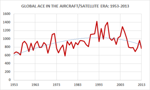
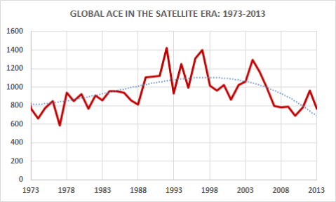
The Bhola Cyclone of 1970: It is also noted that the strongest and most destructive tropical cyclone of the post industrial era was the monster Bhola Cyclone [LINK][LINK]that killed half a million people in Bangladesh and it was in fact the storm that created the nation we now know as Bangladesh. It occurred in 1970 right in the middle of the 1970s cooling period[LINK]that had sparked fears of a return to Little Ice Age conditions[LINK] . THIS CYCLONE DID TAKE PLACE DURING THE ERA OF THE CURRENT GLOBAL WARMING PERIOD BUT DURING THE 1970S COOLING PERIOD AND THE BEGINNING OF THE CURRENT WARMING PERIOD.